Archive
Smultronstället
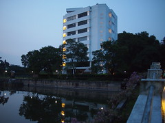
An hour and a half from London’s Stansted Airport, the kindest couple picked us up in Gothenburg, fed us, and ferried us to the most delightful Smultronstället in Aneby, Sweden.


The family home was a former farmhouse built in the 1700s. Its painted timbered walls were a safe nest to rest from the year and prepare for camp. It was strange not to be able to shrug off the overwhelming sense of safety within its walls. I could not figure out whether it was the magnanimous Christian hospitality of the Swedish Boy’s parents (for whom “make yourself at home” really meant that) or the smell of a well-used but clean house or something else. We met his extended family and neighbours – all friendly and curious…
 …and the black cat who alternated between ambushing our bare feet as we walked through the door and purring with delight while cuddling in our arms.


There were delicious barbecues outside their summer house by the Black Lake and refreshing summery fish dinners in the gazebo, all washed down with good quantities of elderflower drinks from the bush in their garden.
 And we were ravenous at dinnertime, because a whole week of sunshine meant: getting on a nose-flipping ferry from Gränna* for a cycling expedition on the island of Visingsö,


with its fields of rapeseed and potatoes, and picnicking by the old castle overlooking the Vättern lake while discussing the biblical imagery of the sea, and eating from cherry trees by the road;


boating up the Black River with its thick forest of reeds and its frogs under lilypads, lazily counting different species of dragonflies, chatting about the use of testimonies and the state of the Swedish church, and staring wonderingly at birds of prey;
 cruiser rides in the sunset, safe in protective black leather and in the care of a strong bear of a man with a soft gentle voice;


berry-picking in the forest – where you stuffed ripe sweet fruits in your parched mouth as much as you added them to the basket. The wild smultron (wild strawberries), raspberries (in short supply due to the late spring/summer), and blueberries that we had the self-control not to consume immediately made for a delightful dessert, with cream and a sprinkle of sugar.
 Had some of the most well-rested nights in a long while. And it was so very very good to be able to have proper conversations about the application of Colossians and also about quantum physics and cosmological theories instead of having to bear the sneering that usually greets any attempt to broach these topics.
So very thankful to God for the worldwide church family, and a little glimpse of what our fellowship in the new creation might look like.
*Gränna, in Jönköping, is also home to polkagris – a peppermint candy. Polkagrisar shops line the streets, enticing tourists and locals alike with the smell of warm sugar spun into different flavoured crunchy sticks.


**much liquorice love, much of which was imported to London to replenish the depleted Copenhagen stock


Cycling and Graffiti in Copenhagen


It’s cycle city central in Copenhagen where almost everyone owns a bicycle and there are dedicated cycle paths on many roads. There are bikes for sale or rent almost everywhere (including free Bycyklen citybikes), bike tours (eg. Bike Mike Tours), and the enthusiastic Cycling Embassy of Denmark. You can plan your cycle routes with Cycle Copenhagen’s trip planner and ride to work from the suburbs on the new-ish superhighway for bicycles. Town planners can take Copenhagenize’s Bicycle Culture By Design study tour to understand the infrastructure and facilities behind one of the world’s top biking cities.
The only reason The Satorialist hasn’t featured Copenhagen in a big way must be that he would go stir crazy stopping the entire Danish gene pool for a photo – preppy boys with their blonde hair undercut, shaded by Ray Ban Wayfarers, dressed in brightly-coloured shorts, on Velorbis rides; girls with their blonde hair in tight buns, in streaming vintage sun-dressies and Ray Ban Aviators; white-haired business men in well-tailored suits and white trousers, dapper with handkerchief in jacket pocket, balancing on vintage Raleighs.


Also a common sight – parents taking the kids out on Christiana Bikes boxcycles and cargo bikes, and on Strøget (the pedestrianised shopped street), bicycle rickshaws for hire.
But all isn’t well in paradise – the number of cyclists on the roads has put a strain on the infrastructure, and led to congestion on cycle paths and impatient aggressive behaviour especially during rush-hour. The Danish government has apparently told campaigners asking for wider paths and multi-storey parking that they have to learn to behave before using public funds for this purpose. In light of the push by a small group of enthusiasts in Singapore for cycle paths, the island’s government might do well to challenge them to come up with viable:
- justifications for the use of public funds to acquire extra land and make extra space to accommodate the wishes a small minority of the population;
- regulations to govern the obligations of cyclists in relation to other road users (and pedestrians). It is easy to claim to be the victim of society and claim that society owes us our self-proclaimed rights, but not quite as easy to think about the rights we owe other people within the same community;
- justifications for the use of additional public funds (if any) to police and enforce these rules.


In Denmark, investment in infrastructure for cycling is logical because:
- a great majority of people cycle. Children learn to ride along with their ABCs, and cycle to kindergarten;
- people cycle because the weather does not discourage cycling;
- people also cycle because fuel prices are high.
And cycling is not the panacea for all that is wrong with society today. Any claims that a cycling city is a kinder city fails to consider that human behaviour, whether behind a wheel or pedaling furiously, does not change. A bicycle is stolen every 8 minutes in Copenhagen, say some statistics. And then there is the road rage.


And aside from any arguments about the artistic merit of street art, the rampant graffiti suggests an intolerance for the property rights of others – something that should not be prevalent in any society, much less a much-lauded “liveable” city.
From Nicoll Highway To Bishan Park By Kallang Park Connector
It is remarkably simple to walk, jog or cycle from Nicoll Highway to Bishan Park, thanks to the Kallang Park Connector. A rather different side of life in Singapore exists along the waterway:


if you start from Nicoll Highway MRT Station (difficult not to think of Heng Yeow Peow), just as the sun is setting, you will see next to the waters, meet-ups and couple-time with the Singapore Flyer and Gardens By The Bay in the background,


“The fountain you see in front of you shoots water to a height of 12 storeys. It was launched by Minister Mentor Lee Kuan Yew during the commissioning of Marina Reservoir on 20 November 2010.
This body of water is part of Marina Reservoir, Singapore’s 15th reservoir and also Singapore’s first reservoir in the city. Water from as far away as Ang Mo Kio gets channeled into this reservoir. The Marina Reservoir catchment is Singapore’s largest and most urbanised, with an area of 10,000 hectares, or one-sixth the size of Singapore.”


Choosing not to notice that Kiki is in town, you can stare at Tanjong Rhu, Pebble Bay, Singapore Indoor Stadium et al surrounding the rest of Marina Reservoir before hanging a left towards Nicoll Highway. (Except that’s not really the rest of Marina Reservoir, since it’s an estuarine reservoir that wanders up all the way to Ang Mo Kio.)


Past Waterways Watch Society vessels and PUB‘s (i think) blue river cleaning crafts,

then under Nicoll Highway to Kallang Riverside Park,


where Burmese, Indian, Chinese groups can be found picnicking under the casuarina trees. Washroom facilities.


Cross the bridge over Sungei Rochor to TURE (66 Kampong Bugis), where you may want to take the opportunity to fuel up at Loysel’s Toy.


If not, turn right after the bridge, past The Spirit of Kallang sculpture (where Filipinos string up badminton nets for a few games during the weekends) made from the supporting pillars and girders of Gasholder No.3 from the old Kallang Gasworks, and follow the path along Sungei Kallang. Keep walking until you hit Sir Arthur’s Bridge and Kallang MRT in the distance.


The aim is to get back along the river next to Kallang MRT where the Kallang Park Connector officially starts, so cross Sir Arthur’s Bridge and look to see if there is an underpass under Geylang Road. All i found were three men cleaning fish, one of whom shouted and rushed at me after i took this photo (i just wanted to note the impassable path to the underpass actually!).


Cross Geylang Road, trundle across Geylang Lorong 1 Bus Terminal, cross Kallang Road and mosey down the side path to the river. Follow the path to Boon Keng Road. If you look back, the Singapore Flyer view makes for a nice place to chill out on the grass with significant other or friend while watching Hindu movies (i’m guessing since it involved Ganesha) on a cheap laptop.


Have to be grateful for the rather exact signs! Cross Boon Keng Road at the traffic light pedestrian crossing and continue along Sungei Kallang.


Here you will see the two tributaries (Sungei Kallang and err, Sungei Kallang) form…yeah…Sungei Kallang (or Kallang River). A drainage reserve, huh.


Go past the Boon Keng Ville flats and Chwee Kang Beo temple and cross the strangely-lit bridge when you come to it. (You may overhear two men sitting on a bench nearby, discussing the disadvantages of the new lights,”Now cannot fish already. Fish there everyone can see you.”)

Singapore Flyer still visible.


Edge along the boundary of Kallang Distripark. You might just about make out two people walking steadily along the grass on the other side of Sungei Kallang. They may suddenly notice you, stand and stare at you until you turn up the stairs. Thus comforted by your imminent departure, they may then resume their pace and head for the cover of the Kallang Bahru Road bridge.

Meanwhile, cross Kallang Bahru Road


and go past the Geylang Bahru flats. This is the point where Sungei Whampoa and Sungei Kallang meet. The River Vista @ Kallang HDB flats are situated at this confluence.

The floating platforms (not jetties?) on the Kolam Ayer ABC Waterfront look promising.

Cross this bridge for the Whampoa Park Connector if you wish.

If not, some thoughtful planner has included a bicycle wheeling ramp for your ride,


so continue along the hive of activity below the Geylang Bahru flats – badminton, basketball, sepak takraw etc are played in earnest here.


You’ll start to see signs for Bishan Park.


Thanks to another wheeling ramp up the overhead bridge, there is no longer the need to risk life and limb dashing across Bendemeer Road with a heavy bike. Onward to the retro National Aerated Water Co. Ltd. building!

Except this “POB” has no wheeling ramp.


Here we are.

At this point, you may want to wander off for some bak kwa (smoked pork jerky?!) from Bee Cheng Hiang to chew on as you go along.


If not, cross Sungei Kallang and head towards an unlit bridge that will take you back to the other side. (Wheeling groove thoughtfully provided.)


Head past this little grove where foreign labourers are lying around chatting on their mobiles, and emerge in the estate with roads named after gemstones.


Turn left up Moonstone Lane and then right towards Topaz Road where there is a fantastic almost untouched retro house.


Down under the Pan Island Expressway (PIE), then, if you’re an office rat riding a 10kg Flying Pigeon (some say 22kg, and it certainly feels that way!), some heavy-duty weight-lifting is in order.


Once you’ve made it to the other side, do a U-ie and push your ride along the scalloped walls of St. Andrew’s Village.


This bridge joins St. Andrew’s Junior College and Chapel of the Holy Spirit to St. Andrew’s Junior School.

Cross Potong Pasir Avenue 1. Until recently a stubbornly Opposition ward, Potong Pasir has a laidback feel to it.


Soon, you will have to dismount and push your bicycle through the underpass under the Central Expressway (CTE). On the other side, you’ll see a heavy vehicle park to your left and ComfortDelgro/SBS Transit across Sungei Kallang.

Woohoo, the distinctive sloping roofs of some Bishan flats. There were a number of people fishing and crabbing next to Toa Payoh Lorong 8. Some had made themselves very comfortable and fallen asleep on mats with the radio on.


Cross Braddell Road. (Yay, wheeling ramp.)


Along this stretch of the Kallang Park Connector next to BCA Academy of the Environment, loads of herons (grey herons?) and frogs in the canal. Also, several maids “walking the dog” with their boyfriends.


Past Kuo Chuan Presbyterian Primary and Secondary schools and Bishan Stadium on the left and SMRT Bishan Depot on the right, under the MRT tracks, then

collaborate and listen.

Bishan Park!
Equipment:
– two pegs/two wheels
– Vibram Five Fingers barefoot sports shoes
– Move Collective’s Bobble filtered water bottle
While commenting on the ease of navigating between Nicoll Highway and Bishan Park, we realised that signposts and streetlamps are quite recent phenomena and certainly limited to some parts of developed countries. The writer of Psalm 119 might have had this sort of help in mind when he referred to the Word of God as “a lamp for my feet and a light for my path”. Life seems as if we have suddenly woken up in the middle of a forest, or somewhere in a vast terrain, and there are no visible paths, or perhaps there are many paths radiating away from us. We don’t even know where we are meant to go, so which path to choose? Which direction to take? Everything seems meaningless. Which stranger along the way can we trust? Which signpost (if any) can we rely on?
The Bible is a brilliant navigation device because it tells us why we are here, where we are going, and how we can get there. And, as far as human experience can tell, it is trustworthy because of its historical veracity and internal consistency. Whew.
Recce-ing Pulau Ubin on Bicycle
Took a Raleigh All-Terrain to the Pulau Ubin trails for a recce and the Ketam Mountain Bike Park for some fun (but only managed part of the wimpy Blue Square though as the sun was already setting, but the Double Black Diamond stuff looks like adrenaline rush on a stick!). Will return!

Possibly because the people who use Ketam are generally padded with protective gear, more skilled on two wheels and careful because of the inherent risk of off-road biking, the serious cycling accidents on the island have historically taken place on paved roads outside of the Mountain Bike Park, mostly along Jalan Batu Ubin (near Belatok Hut. A Chinese tourist had a fatal accident here in 2011), along Jalan Mamam (the road leading to Chek Jawa Reserve) and along Jalan Wat Siam “Cemetery Hill” (two fatal accidents: one in 2010 and one in 2006).


Otherwise, quite lovely to trundle down different tree-lined paths,

glimpsing moss-covered staircases through the bushes,

past brightly-coloured old attap houses framed by flowering hibiscus plants or verdant countryside,


and little ponds (with and without lotuses),

and disused quarries,

and large bunyan trees, aerial roots presiding over still waters, with air so quiet you can smell where a trekker stopped to spray some Off! mozzie repellant,


then to burst out of the forest to the sea-shore, take off the helmets and ruffle sweaty hair in the salty sea-breeze.
Communing with nature off the beaten path, at least in Singapore, always requires all senses to be on high alert – there are mosquitoes and other biting insects in the air; scorpions and snakes in the undergrowth; more snakes, some poisonous spiders and sometimes aggressive monkeys in the trees etc. So there are some who say that few unbelievers live close to the wild, that is, when one cannot control one’s environment and is always a bite away from death, one believes in some higher power (as the many temples around indicate, including one dedicated to a German girl). Generally, i’d have thought it more prudent to trust someone with a good track record of being in control of things and caring about humans, above one who has difficulty taking care of him/herself and/or needs to be cajoled into providing some protection.

snakes = 0,
St. Andrew’s Cross spiders = 1 which was soon paparazzi-ed,
monkeys = at least 20. an extended family gathering blocked the path to Chek Jawa

Plenty of bicycle rental places in Ubin Town (the advertised S$2 rental may not apply to weekends or adult rides), or

taxis (minibuses really) can be rented from the uncle sitting next to a tankful of crabs and a weighing scale to the left of the public jetty.


To get to Pulau Ubin, hop on a bumboat from Changi Point Ferry Terminal. They leave when there are 12 people or when the boatowner feels like it. S$2.50 per person, S$2 per bicycle. Charter an entire boat if you’re bringing pets so as not to inconvenience those whose religions oblige them to consider certain animals (eg. dogs – yes, even that hypoallergenic labrapoodle) unclean.

Several villagers sell cold drinks in/in front of their houses. The drinks are generally more expensive than on mainland but considering the cost of bringing the drinks across the sea, the fact that local islanders have little in the way of other livelihood, and general principles of demand and supply, prices quite alright (and still cheaper than 7-11!).
*the blur on some of the photos wasn’t added to suggest the romance of nature. My sweat got onto the lens, dried, and left behind little crystals. Just in case anyone was wondering…


